No.1
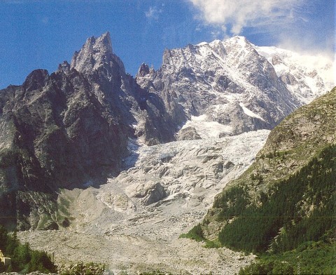
A rock avalanche on the surface of the glacier at the foot of Mont Blanc.
Mont Blanc is the highest mountain in western Europe. Its height is about
4,810 meters. This photograph was taken from a point near the entrance
on the Italian side of the Mont Blanc Tunnel in the 12th overseas excursion
to the Alps sponsored by JSEG on August 25, 2004. Brenva Glacier characterized
by rugged clustered seracs, is situated between Black-Aiguille (2,922m)
on the left-hand side of the Mont Blanc glittering in a silver color and
an arete of Brenva Aiguille on the right. This glacier is once interrupted
by a steep slope of the glacial steps down below where massive jointed
rocks crop out with a bumpy surface texture. A large amount of gray debris
is distributed on the basal part of this slope without a landform characterized
by glacial deposits. Crevasses on the surface of the debris indicate the
presence of the concealed glacier flowing as a black glacier. This place
is a terminal part of the trace of the rock avalanche on January 18, 1997,
caused by a large-scale rock collapse occurred in the upstream area of
the glacier.
(Photographed by Shuichi HASHIMOTO)
No.2
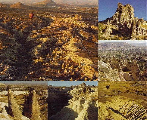
The District of Cappadocia located at the central portion of the Anatolia Peninsula, Republic of Turkey, is registered as the National Treasure because of its view of the unique erosion topography, and historic and cultural values of the ancient-city sites.The strange rocks with bamboo shape, are the column-shape remains resulted from the erosion of volcanic sediments. Some rocks have basaltic rocks on the top like hats. Now, we can enjoy this unique view on the air balloon ride. The Catholic had lived in this area form A.D. 4 C. They built the underground cities by boring the basement of tuff,in order to escape from persecution of the Rome Empire. At its peak, they built the underground cities including monastery, schools, depository of foods, graves, other than houses. Around 20,000 people are believed to live there.
(Photographed by Hiroshi Oshima)
No.3
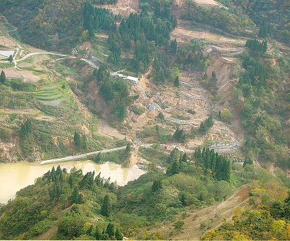
Terano landslide caused by 2004 Niigata-Chuetsu earthquake.The earthquake occurred around 5: 56 pm October 23, 2005. Within an hour after the main quake, many aftershocks followed, including two uppers 6 quakes on the Japanese earthquake scale. These quakes caused more than 1,000 slope disasters in and around the former Yamakoshi-mura area. The cover photo of this issue, which was taken one week after the occurrence of the initial tremor, depicts a landslide damming back the Imo River. The geometry of the trees under the main scarp of the landslide, the sub-scarps in the moving blocks, severed asphalt roads, the alignment of tree stands, etc. shown in the picture suggest the pattern of the mass movement. It also shows the rise of the water level of the Imo River due to the damming effect.
(Photograph by Tsuyoshi Haraguchi)
No.4
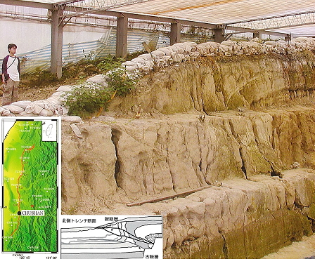
The north wall of the trench dug on the Chelungpu Fault at Chunshan, Taiwan.
In the left below map1), red broken line shows the trace of Chelungpu Fault
which is the surface rupture occurred at the Chi-Chi Earthquake 1999, and
solid circle shows the location of the trench.
The center below sketch2) shows the geological structure of the trench
wall, and there are several faults which occurred at various age.
The vertical displacement of this point at the Chi-Chi earthquake is about
2m, and the horizontal displacement is about 3.5m.
These displacements are not only cased by faulting, but also mainly by
folding in the hanging wall side.
(Photographed by LIN, Weiren and YEH, En-Chao)
1) Ma et al. (2003) : Evidence for fault lubrication during the 1999 Chi-Chi,
Taiwan earthquake (Mw 7.6), GRL, vol.30, 1244, doi : 10. 1029.;
2) http://ashan.gl.ntu.edu.tw/chinese/earthquake
No.5
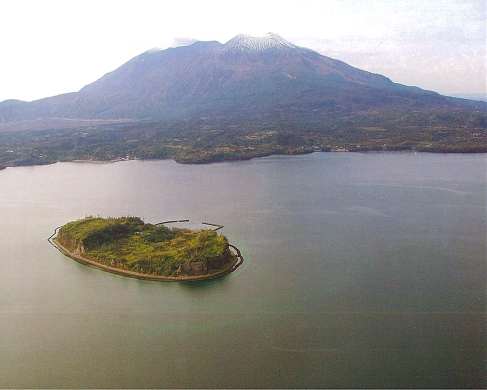
Aerial photograph of the Sakurajima Island and Shinjima (Moejima) Island.
The Moejima Island was formed through the upheaval of the see floor caused
by the magma intrusion that resulted in the Annei eruption(1779~1780) of
the Sakurajima Volcano. The Moejima shirasu is dominantly distributed on
the island and the Moejima shell bed overlies it. Plenty of Neopycnodonte
musashiana, which lives in deep water of a depth of about 100 meters, is
contained in the Moejima shell bed. The beach erosion for 200 years after
its formation has been so remarkable that the island’s area has been significantly
reduced and the island is now under the preservation by wave dissipating
concrete blocks and revetments.Several volcanic active faults with a throw
of over 20meters in east -west trend can be seen in the island.
(photograph by Tuyoshi Haraguchi 2004/12/30)
No.6
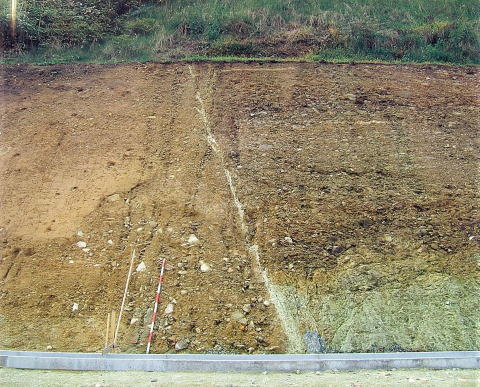
Outcrop of an active fault which is the east end part of Kidoyama-seihou
fault of Ohara fault system.
A beautiful active fault had appeared in a cut slope in the construction
works of proposed prefecture road Sakoda-Shinome line in Shinomenakago
Area, Ato town, Yamaguchi prefecture. Fault gouge, which is ten-centimeter-thick,
white to greyish white color and originated from the bed rock, clearly
continues in a gravel layer. One meter height of fractured bed rock at
the toe of the slope can be seen in the north side of the fault with fault
gouge. This bed rock covered with firm gravel layer is rhyolitic tuff belongs
to Shinome formation Abu group. In the south side of the fault, the bed
rock cannot be seen, and well grained and loose gravel layer contacts with
the fault.
(Photographed by Takuya MORIOKA)