No.1
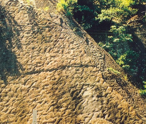
“Fossil Ripple Marks at Shishikui-ura” crops out on a face of slope of
a coastal road in Shishikui Town, Tokushima Prefecture, Japan. They are
fossil current ripples on a bedding plane in sandstone-rich alternating
beds of sandstone and mudstone of the Naharigawa Formation , deposited
during Eocene within the Shimanto Belt. They are Natural Monument of Japan
and are said as the largest and the most beautiful fossil ripple marks
in Japan.
(Photographed by Wakio SUIDO)
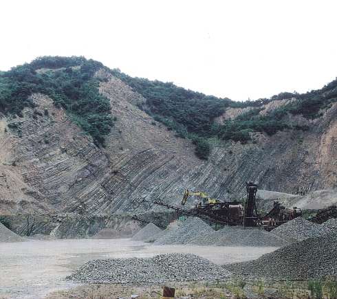
No.2
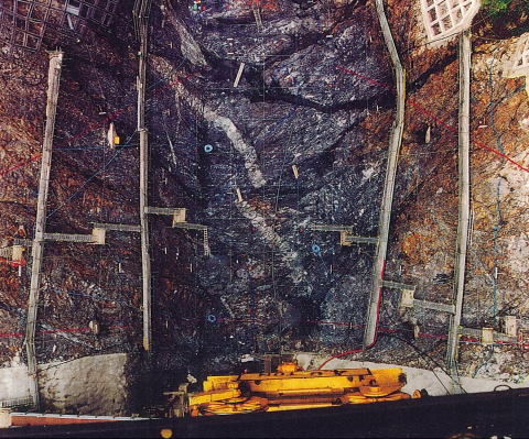
Figure shows that an excavated base for the Mikawasawa Dam exposes Mesozoic
sandstone and shale with porphyrite intrusion, which belong to the Ashio
Accretionary Complex located in the northern Kanto district in Japan. The
dam is a concrete gravity dam by the RCD method for multi-purpose use.
Its dimensions are 48.5 m in height, 97.5 m in length and 28,367 m3 in
volume. In the central part of the photo an almost vertical dyke of the
pale colored porphyrite intrudes into the sedimentary rocks. Some right-lateral
displacements of the dyke are caused by faults running parallel with the
bedding planes. The sandstone beds consist mostly of lens and blocks of
sandstone, and show a large variation in the strike direction. This sandstone-shale
complex is interpreted as olistostrome. The interval between white lattice
lines is 5 m. Red lines indicate outline of the dam.
(Photographed by Seiji NAKAO)
No.3
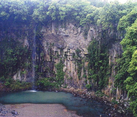
Photograph is the outcrop with 50m high of Welded tuff (Aso-4A Volcanic pyroclastic flow). This large outcrop is situated at Deai bridge located around Krio ,Ogata-tyo, Ono-gun, Oita prefecture ,Kyusyu district, where large columnar joints with 1 to 2 m in breadth are developed. Columnar joints extended regularly from top and bottom, and entablature of middle portion are observed clearly. A few meters rocks separated from joints plane and collapsed.
No.4
The formation of fracture or small fault in geological layer depends on the particle size of the clastic grain. While the conjugate fault and parallel small faults develop methodically in the sandstone layer on this outcrop, a lot of irregular small cracks and fractures with few centimeters width develop in conglomerate.These photographs are taken at Shirahama of Kamiko Motojima in Izu peninsula. Widths of all photographs in right column are approximately 1m.
(Photograph by Mr. Kazuo Kosaka)
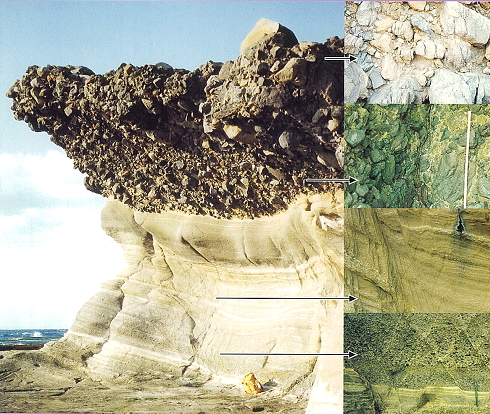
No.5
Outcrops of Izumi group in a quarry site located in Seto town, Naruto city,
Tokushima prefecture, Japan.
Izumi group is considered as a marine-origined stratum in the late Cretaceous
(Champagne period). These outcrops here belonging in Izumi group, which
sedimentary rocks in alternating beds of sandstone and mudstone with 40~60%
sandstone share, is classified " sandy mudstone facies". Many
sandstone beds with several 10cm~1m thickness are found in these outcrops,
and characteristic sedimentary structures such as graded bedding and slump
structure are observed in these sandstone beds.
(Photographed by Tsunehiro YOSHIDA)
No.6
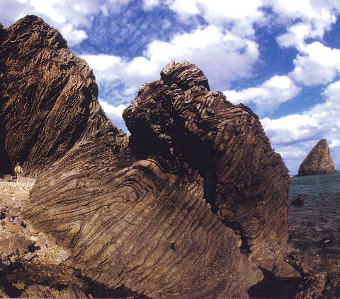
The photograph is showing an outcrop of the Kayo Formation (alternating beds of sandstone and shale, or those of sandstone and slate) characterized by folds. On the successive sea cliff of the Pacific coast from Teniya to Banzaki in the City of Nago situated in the northern part of the main island of Okinawa, Japan, pre-Tertiary turbidite strata of the Kayo Formation (correlative to the Shimanto belt) crop out and exhibit conspicuous folds. Most of these folds are in the form of anticline, the axial plane of which is facing southeastward (dipping northwestward). These folds presumably form a part of decollement resulted from the subduction of the Kula-Pacific Plate.
(Photographed by Tetsuo AMAYA)